
The Philippines is one of the most affected areas in the world in terms of natural disasters, including earthquakes, typhoons, volcanic eruptions, and floods. The catastrophic effects of anthropogenic climate change often manifest in the country in the form of typhoons. Readers may remember Typhoon Yolanda (Haiyan) in 2013, one of the most powerful typhoons in recorded history and (as of this writing) the deadliest typhoon in Philippine history.
One of the ways we track typhoons today is through weather satellites, which bring some form of predictability to weather patterns and allow us to plan accordingly to reduce damage and casualties caused by typhoons. The Philippines, on average, experiences approximately 20 typhoons per year. But who made this possible, and what did it take to accomplish this? My research led me to the Television Infrared Observation Satellite (TIROS-1), also known as TIROS-A, which was the first weather satellite in existence.
The Cold War began almost immediately after World War II. The United States and the Soviet Union sought not only to dominate geopolitical affairs but also to extend their rivalry beyond Earth and into space. While the Soviet Union achieved this first with the Sputnik satellite in 1957, the United States sought to outdo its rival superpower. The TIROS project was promoted by meteorologist Harry Wexler (1911-1962). It involved several government agencies and corporations, namely the Advanced Research Projects Agency (ARPA, now DARPA), the National Aeronautics and Space Administration (NASA), the Radio Corporation of America (RCA), and the National Oceanic and Atmospheric Administration (NOAA) among others across the scientific, military, and technology sectors.
The concept for TIROS emerged as early as the late 1940s, with studies continuing into the 1950s. A committee headed by William Welch Kellogg of the RAND Corporation, with representatives from various branches of the United States military, eventually concluded in 1958 that the program should provide observations of cloud cover with television cameras at coarser and finer resolutions, coupled with infrared measurements of the Earth’s radiation. The development of TIROS was initially classified information, meaning that only select members of the United States government were privy to this information. The development of the satellite was contracted to the Army Signal Corps Laboratories for USD3.6 million, although the exact date is unknown (assuming 1960 dollars, this would be ~USD39.1 million in 2025).
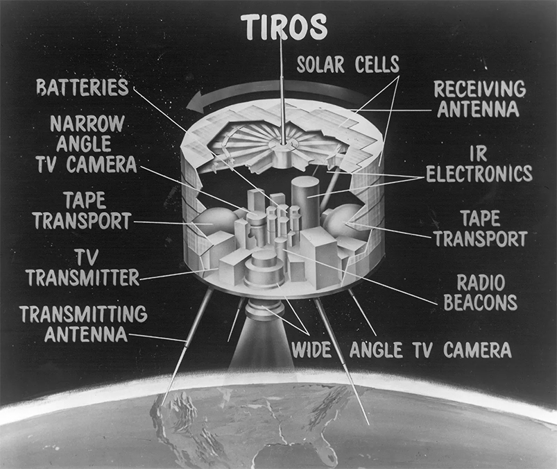
The initial design called for three separate satellites, each with a two-lens optical television system, an improved infrared scanning system, and a radiometer to measure Earth’s energy budget. While we can delve more deeply into the science behind such an invention, in brief, these were the primary objectives of the TIROS program. TIROS-1 launched on April 1, 1960. This satellite initially featured only a two-lens optical television system, but additional features were added later with the launches of TIROS-2, TIROS-3, and TIROS-4. The original TIROS series was commissioned from 1960 to 1967, while newer satellites were launched all the way until 2009.
What did TIROS-1 accomplish? It proved the feasibility of using satellites to observe global weather patterns. While it didn’t have an impact on news coverage, it did improve weather forecasting, encouraged improvements on future similar satellites, and enabled weather to be observed from space, allowing humanity to see the impacts of anthropogenic climate change in real-time. As of this writing, all of the original TIROS satellites, with the exception of TIROS-7, are still in orbit. TIROS-1 provided us with actionable data to address the challenges posed by the weather, and we should be thankful for such an invention.
Words by Jose Alvarez
Also published in GADGETS MAGAZINE Volume 25 No. 11 Issue.